
Perspectives of Earth:
Sharing Our Vision

The McAuliffe Center is inviting individuals to document the environmental challenges that affect their towns and neighborhoods, reflect on the environmental challenges’ consequences on life in their local communities, and share with us ideas for potential solutions to counteract the negative effects of environmental degradation.
Each day during Earth Week, April 22 to 26, we will feature an image of planet Earth taken from space on the McAuliffe Center’s Twitter and Instagram accounts. We will provide additional information and prompts for discussion. We invite all to share images that document local environmental challenges with reflections and potential solutions on social media using #PoEVision!
We need your creativity and innovation to solve, today, the problems that threaten to impact the next generation.
Individuals can engage in this activity any time before Earth Week 2024. You are invited, however, to share reflections and images during the period of April 22 to 26 with the McAuliffe Center’s Twitter and Instagram accounts by using the hashtag #PoEVision.
Activity Guide:
Choose any of the images featured below for discussion.
Choose to devote time to this activity.
You can reflect with others or you can reflect individually.
… Or, you choose the best format for you!
Collect full-length reflections, potential solutions, and images (when possible) and turn thoughts and images into social-media-length posts (up to 280 characters long).
Post the reflections and images with the McAuliffe Center’s Twitter and Instagram accounts by using the hashtag #PoEVision.
Questions?
Contact: Suzanne Wright, swright4@framingham.edu
Write “PoE - Sharing our Visions” in the subject line of your email
Choose one of these images to start your discussion:
Monday, April 22
Heat Islands, Ground Cover
Can you identify heat islands in your community? Share your images and reflections.

New York City, Credit: NASA - ISS039-E-18538
As many urbanites know, summertime has its downside. The things we take for granted in cities—roads, sidewalks, brick buildings, and asphalt roofs—all intensify summer heat by trapping the Sun’s energy and remaining warm long after the Sun has set. This phenomenon has a name: urban heat island.
Share your reflection directly on social media using #PoEVision
Tuesday, April 23
Deforestation, Climate Change
Are you noticing deforestation practices in your community? Share your images, reflections, and ideas for action.

Amazon River, Credit: NASA - ISS064-E-14990
Deforestation is destroying forests at an alarming rate. This is of great concern because they play an important role in global climate and are home to a wide variety of plants, animals, and insects. Over 60% (3.1 million acres) of Massachusetts is covered with forest, but deforestation is affecting our state, too. According to Massachusetts Audubon, over 40 acres of open space (forests and field) are lost to development every day.
Share your reflection directly on social media using #PoEVision
Wednesday, April 24
Hurricanes, Climate Change
During the last few months, did your community experience flooding or tornado warnings due to the hurricanes that made landfall on the east coast of the United States? How can we be better prepared to deal with the impacts of future hurricanes?

Hurricane Ida, Credit: NASA, European Space Agency
Hurricanes are the most powerful weather event on Earth. The "what" of hurricanes is seen through amazing NASA images. Other NASA data helps researchers contribute to hurricane science and understandings of how we can be better prepared to deal with their wide range of impacts.
Share your reflection directly on social media using #PoEVision
Thursday, April 25
Drought
Are you aware of the effects that drought may have on your community? Share your images, reflections, and ideas for action.
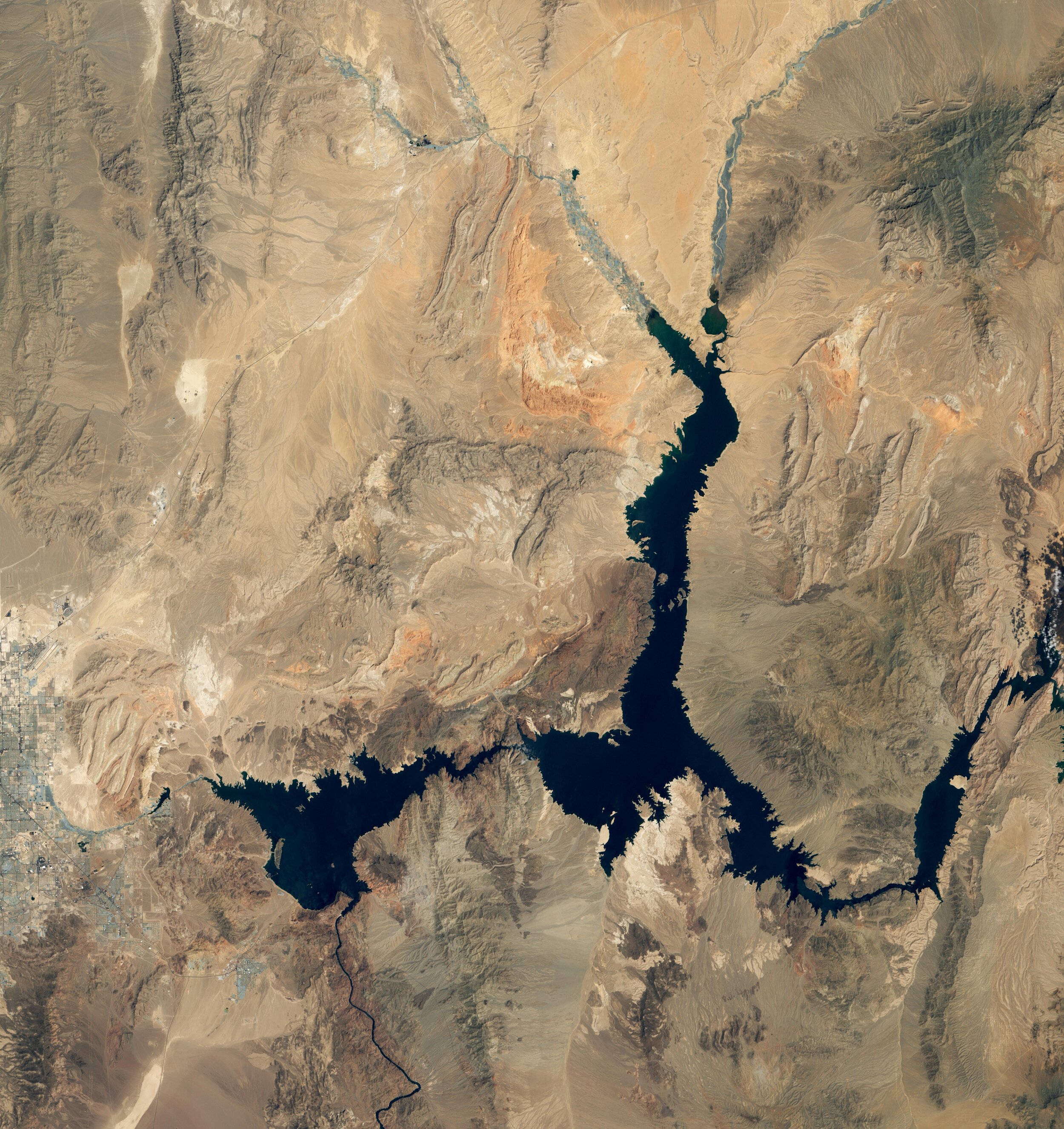
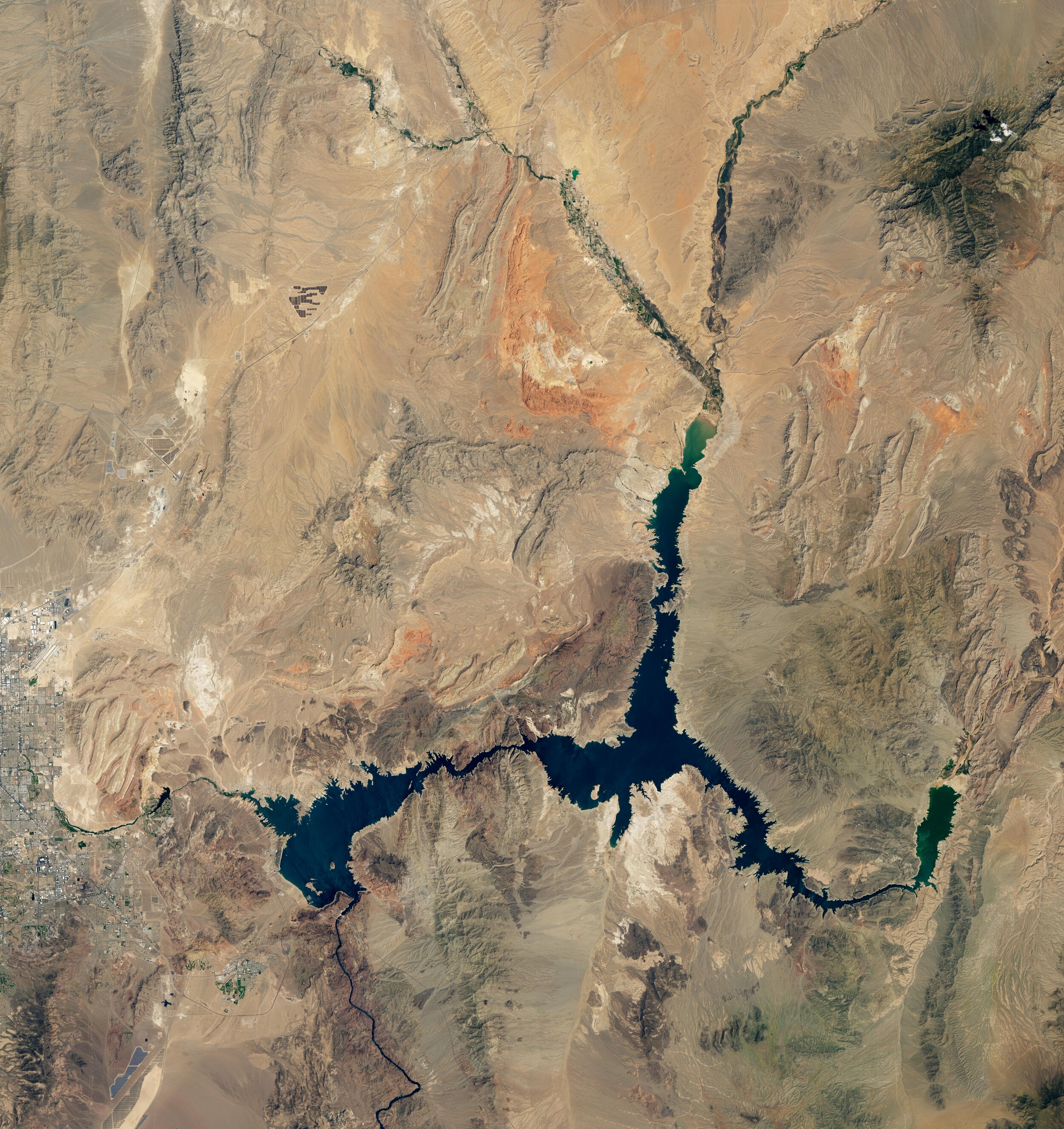
Lake Mead is the largest reservoir in the United States and part of a system that supplies water to at least 40 million people across seven states and northern Mexico. It stands today at its lowest level since Franklin Delano Roosevelt was president. This means less water will be portioned out to some states in the 2022 water year.
Credit: NASA Earth Observatory
Share your reflection directly on social media using #PoEVision
Friday, April 26
Air Pollution
Are you concerned about air quality in your community? Share your images, reflections, and ideas for action.
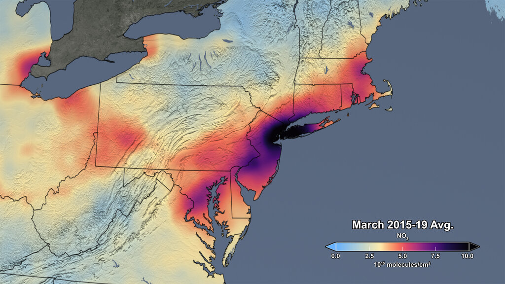
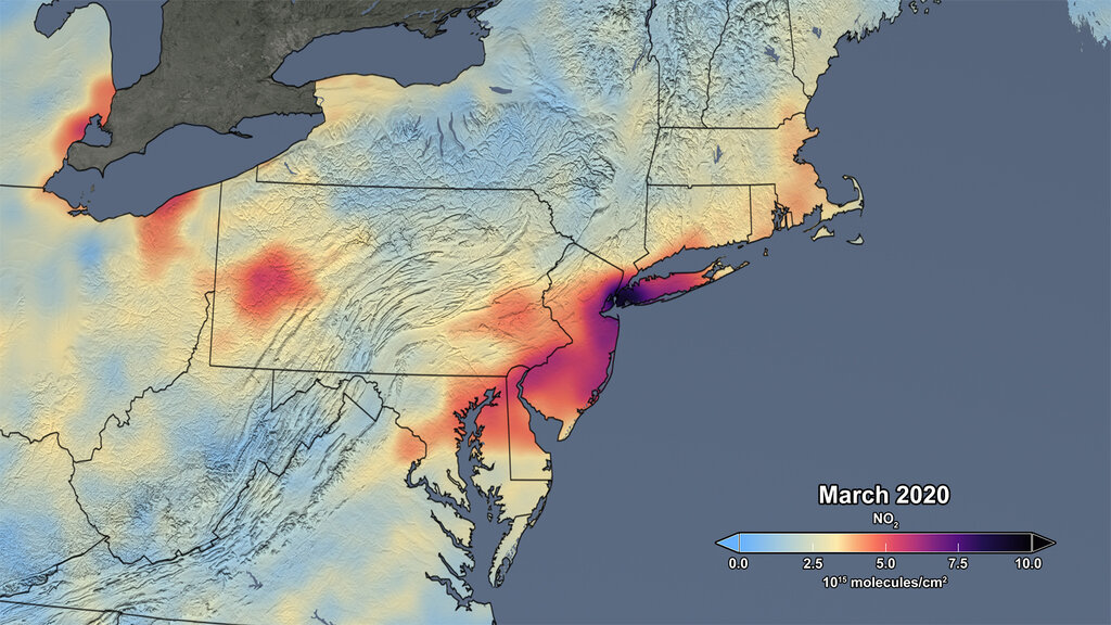
Credit: NASA's Scientific Visualization Studio
Nitrogen dioxide (NO2), primarily emitted from burning fossil fuels for transportation and electricity generation, can be used as an indicator of changes in human activity. These images show average concentrations of atmospheric NO2 in March from 2015 to 2019, and the average concentration measured in March 2020. Breathing air with a high concentration of NO2 can irritate airways in the human respiratory system. Longer exposures to elevated concentrations of NO2 may contribute to the development of asthma and potentially increase susceptibility to respiratory infections.
Share your reflection directly on social media using #PoEVision

